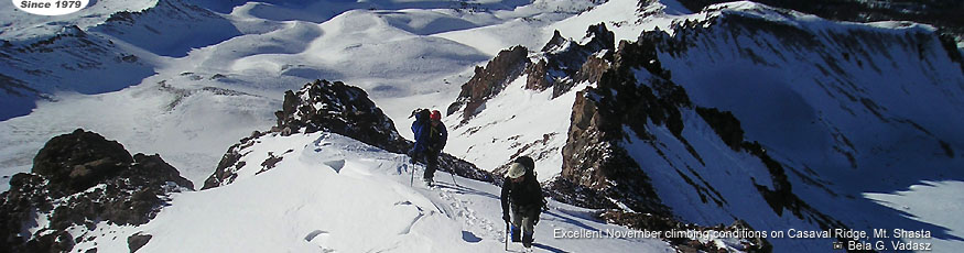
Technical Difficulty (Class):
Click to see rating Click on rating

Prerequisite Skills:
Click to see rating Click on rating

Physical Condition:
Click to see rating Click on rating

Client/Guide Ratio: 3:1

Includes:
All guides auxiliary and group climbing gear, use of avalanche transceiver, probe and shovel, all group camping gear: tents, stove, fuel cook kit and 2 mountain dinners.

Does not include:
$20 USFS Summit Pass. Annual passes are available for $30.


Operating under Special Use Permit, Shasta Trinity National Forests

Mt. Shasta Climbs & Seminars

Mt. Shasta, Casaval Ridge     3 Day

The asthetic route proportionately rivals the famous Peuterey Ridge or the Brenva Spur of Mt. Blanc in the European Alps.

This extremely interesting and potentially challenging climb is the experienced climbers first choice on Shasta in winter, when loose rock is covered in snow yet providing high ground ridge travel to reduce exposure to winter avalanche hazard. From a high camp around 10,200', among the spectacular rock gandarmes, we'll attempt the summit and return to high camp. Snowshoes or short approach skis will be necessary, along with previous ice axe, crampon and snow camping experience.

REGISTER >>>
Cost: $725

Dates:
Dec 8-10, 2017 (Fri-Sun)


Skills covered will include:
  • Planning and preparation
  • Equipment selection
  • Packing technique
  • Over-snow travel technique
  • Avalanche and hazard assessment
  • Use of avalanche transceiver, probe and shovel
  • Climbing with ice axe, crampons, harness and rope
  • Campsite selection and construction
  • Meal preparation, nutrition and hydration
  • High altitude pacing
  • Long-climb time management
  • Descending skills
Even if weather does not safely permit a summit ascent, this attempt will be packed with valuable skills building and true, winter mountaineering adventure.


The Approach:
From Bunny Flat (6,860'), the end of the plowed road in winter, we begin with a gradual ascent to Horse Camp and the Sierra Club Cabin (7,880'). From here, we leave the standard route and access the base of Casaval Ridge, a short distance from the Hut. Following the broad ridge we will climb to about 9,800' or continue to about 10,200' and choose our best campsite option based on the weather and conditions.

The Climb:
From our camp, we'll continue ascending the ridge until it increases in steepness at 10,800' at the "First Window". We bypass the gendarmes or rock towers, often on the left (N), though sometimes on the right depending on how the snow has accumulated. At 11,800' we reach the second window climbing around more steep towers. After a few short, steep sections around 13,000', we attain the SW Summit at 13,384', traverse the flat plateau and gain the regular route at about 13,500' and follow it to the Summit at 14,162'.

The Descent:
We more or less descend the same route as as the ascent. Depending on snow conditions and avalanche hazard, we sometimes choose to descend portions of the West Face back to a traverse leading to our high camp. We then choose the best descent back to horsecamp based on conditons.

Preparation:
Cardiovascular conditioning: prepare with at least 4-5, 60 min+ aerobic workouts per week including hill running, biking, or hard-hill hiking with a pack and ski poles. Pre-climb acclimatization recommended to include hiking and sleeping at 8,000' or higher 1 or 2 days before the climb.


Prerequisites:
  • Excellent physical condition prepared for long, rigorous days in possible adverse conditions
  • Previous off-trail hiking (5+ miles)
  • Previous elevation gain of over 4,000' in one day
  • Previous highcamp camping skills on a multi-day route
  • Prepared for possible harsh, sub-freezing winter conditions and high winds
  • Experience with ice axe and crampons including movement in balance, self-belay and self-arrest skills
  • Belayed climbing with rope and harness, preferrably with crampons
This climb is for experienced climbers prepared for challenging conditions.


Questions about this climb?

Name:  Email:


   Equipment List
   Logistics

   Shasta Area Map
   Shasta Topo Map

   Avalanche Forecast
   Weather Forecast
   Road Conditions

   Leave No Trace
   Trip Insurance
©2012 Alpine Skills International  
Site Map